It’s a good practice to explore hiking trails depending on where you are in Kauai. If you are choosing to stay on the north shore, we have some exciting trail choices for you.
Most of these treks are muddy, strenuous and have an element of danger involved. It’s important that you assess your abilities and choose the trek of your choice.
For this purpose, we’ve covered each of the following trails in detail. Let’s explore them one by one:
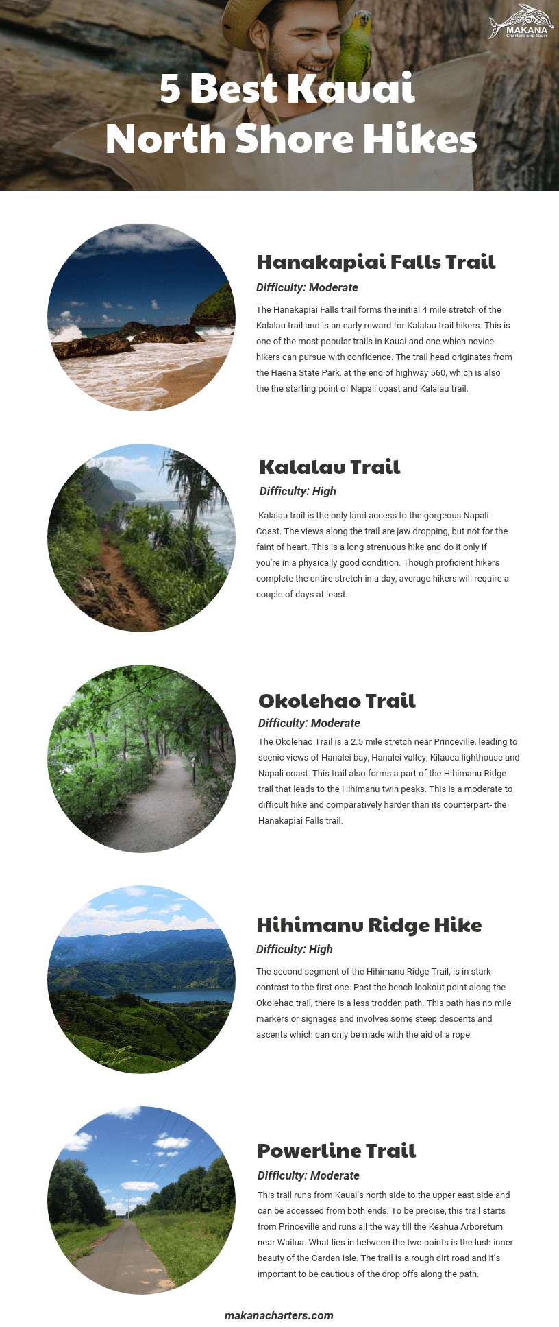
Hanakapiai Falls Trail (Difficulty: Moderate)
This is one of the most popular trails in Kauai and one which novice hikers can pursue with confidence. This is an easy to moderate hike and will constantly test you with steady elevation. However, if it rains, the trail can get slippery and a little bit wicked.
The Hanakapiai Falls trail forms the initial 4 mile stretch of the Kalalau trail and is an early reward for Kalalau trail hikers.
The trail head originates from the Haena State Park, at the end of highway 560, which is also the the starting point of Napali coast and Kalalau trail.
The journey to the falls and back is 8 miles round trip. The first mile gradually takes you to an elevation of over 400ft with splendid views of Napali coast and Keé beach’s coral reefs.
The first 2 miles, which lead to the Hanakapiai beach, are suitable for an average hiker and there are great views along the way. Hanakapiai beach is a regal setting which serves as a post-hike relaxation point. However, swimming in the beach can be dangerous, as suggested by numerous sign boards in the area.
The next 2 miles towards Hanakapiai Falls, add a level of difficulty to the hike and challenge your hiking muscles.
Except for seasoned hikers, most people return from Hanakapiai beach. If you are willing to do the next 2 mile segment of the hike, take a few minutes to relax on the beach and continue the hike inland with renewed vigour.
The trail to the falls is less defined and passes beside the Hanakapiai stream. There are numerous stream crossings along the way. Exercise extreme caution while crossing the streams as they are prone to flash floods.
After all the exertion, you will be graciously welcomed by the 300 foot waterfall that originates from the depths of the jungle and plunges into an azure pool. Relieve your fatigue by taking a dip in the pool. Owing to the temperature in this region, don’t be surprised if the waters are ice cold.
Overall, the hike is characterized by slippery soil, tree-roots, rocks, streams, bamboo forests and some stunning views.
Kalalau Trail (Difficulty: High)
Here comes one of the world’s most beautiful yet dangerous hikes. Kalalau trail is the only land access to the gorgeous Napali Coast. The views along the trail are jaw dropping, but not for the faint of heart. This is long strenuous hike and do it only if you’re in a physically good condition.
Spanning 11 miles in total, Kalalau trail begins at Keé beach and ends at the Kalalau valley.
Though proficient hikers complete the entire stretch in a day, average hikers will require a couple of days at least.
The only available camping sites are at Hanakoa valley and the Kalalau beach. You will need an overnight camping permit to hike past Hanakapiai Falls. Being caught without a permit is considered a serious offense.
There are two beaches along the trail. One is the Hanakapiai beach at 2 miles, and then the Kalalau beach at the end of the trail. The ocean currents are strong and swimming is not recommended.
Past the Hanakapiai beach, there is lots of mud and it’s recommended to carry hiking sticks for support. The majority of the first 6 miles is uphill, which means, it’s a steep descent on your way back.
At some point past mile marker 4, you’ll get a glimpse of the entire Napali stretch you are about to hike. Though the view is mind boggling, the thought of hiking till the end can be daunting.
Crawlers Ledge: Thrillseeker’s Delight
Gradually, the rocky landscape and the jungle setting is replaced by narrow ridges over the cliffs. Past mile marker 6 (which is barely visible), you’ll soon reach the camping ground at the Hanakoa valley. Here onwards, the remaining portion of the hike is comparatively easier than the first part (Until you reach the crawler’s ledge!)
The hike through crawler’s ledge is very challenging and requires that you grab onto the handheld supports on the cliff wall. There’s a good chance that the trail will be eroded in some portions. Exercise extreme caution as one small mistake can prove to be fatal.
Once you emerge victorious past the crawlers ledge, a few miles further and you’ll finally reach the Kalalau beach. This is the end of the trail and also, your second camping spot. Though the place is secluded, don’t be surprised if you find long term campers for company.
During the winter months, the trail is the muddiest which adds to the level of difficulty. Considering the dangers and risks involved, there is absolutely no doubt about Kalalau trail qualifying as one of the world’s top 10 deadliest hikes.
Do this hike for the journey and experience, rather than the destination. There are numerous lookouts along the way and you will return with a memory to cherish for a lifetime.
Okolehao trail (Difficulty: Moderate)
The Okolehao Trail is a 2.5 mile stretch near Princeville, leading to scenic views of Hanalei bay, Hanalei valley, Kilauea lighthouse and Napali coast. This trail also forms a part of the Hihimanu Ridge trail that leads to the Hihimanu twin peaks.
This is a moderate to difficult hike and comparatively harder than its counterpart- the Hanakapiai Falls trail. The first mile is a steep hike following flat land. There are no views along this portion and there is initial work to be done before you reap the reward.
The first lookout point, which is under the power lines, offers views of the taro fields and the famous Hanalei Bay. Follow the trail a little further and you’ll reach the lookout with a bench. This is the final lookout point and is at an elevation of 1250 ft. This vantage point offers a clear view of Hanalei Bay and serves as a well deserved resting spot.
The Okolehao trail is not well signaged like the others. So be cautious of the path you are following. Rainfall in this part of Kauai is pretty common. Similar to the other trails in Kauai, you can expect this one to be muddy too.
The trail is uphill throughout, which makes the return journey difficult because of the pressure on your legs. So, make sure you are physically fit before proceeding with the hike.
Overall, this is a picturesque setting with rich foliage, chirping birds and beautiful views as you’ll be mostly hiking through the forests.
To reach the trailhead, go past Princeville and turn left immediately after crossing Hanalei bridge. Stay along the Ohiki road until you reach the parking lot.
Hihimanu Ridge Hike (Difficulty: High)
Still got some juice left after the Okolehao trek? If yes, you can continue hiking towards the magnificent Hihimanu twin peaks.
The second segment of the Hihimanu Ridge Trail, is in stark contrast to the first one.
Past the bench lookout point along the Okolehao trail, there is a less trodden path. This path has no mile markers or signages and involves some steep descents and ascents which can only be made with the aid of a rope.
The trail becomes trickier as you proceed and dependability on the ropes goes on increasing. This is a hardcore military style hike where you’ll find spots with as much as 80 degree inclination.
Once you get past the almost vertical wall, the trail becomes narrower and the heights become more pronounced. Eventually you’ll reach an overlook which offers a magnificent view of the twin peaks.
From here, you can bask in the success of having climbed the first peak or get ready for the next one. As per the locals, the hike to the second peak is dangerous and is not everyone’s cup of tea. If you’ve the guts for it, the top of the second peak offers a 360 degree panoramic view of the rainy mountainous backdrop.
Since there are no signposts, you’ll be constantly bombarded by the thought of being lost. It is better to wear gloves as the ropes can be harsh on your hands.
Though the views are soothing to the soul, this trail is not recommended unless you are an expert hiker. If you are just looking for views, stop at the Okolehao lookout.
Powerline Trail (Difficulty: Moderate)
This trail runs from Kauai’s north side to the upper east side and can be accessed from both ends. To be precise, this trail starts from Princeville and runs all the way till the Keahua Arboretum near Wailua.
What lies in between the two points is the lush inner beauty of the Garden Isle. The trail is a rough dirt road and it’s important to be cautious of the drop offs along the path. This dirt trail was created for the installation and maintenance of power lines to Hanalei.
The Powerline trail starts from Kapaka street, up the road from Princeville Ranch stables. Drive 2 miles to the parking lot and start the trek.
Though you can start from the east side, the most scenic view is from the Princeville side. The elevation change is not much and the ocean views and waterfalls call for a memorable experience. A few miles down the trail and you’ll be in for a splendid view of Mount Hihimanu, Mount Namolokama and headwaters of Waioli Stream.
The trail is 13 miles long and is a muddy trek. You can cut the trek short by turning back once you have savored the views, instead of ending up on the other side of the island.
Best Trails in Kauai: A Visual Breakdown
Kauai is a paradise for hiking enthusiasts. If you are one, there is a lot of adrenaline rush waiting for you. If you are a beginner, it’s recommended that you start with less difficult hikes and have a safe experience.


