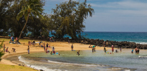
Located in the island town of Kukuiula, Mount Waialeale plays a key role in placing Kauai in front of the world. Standing at an elevation of 5148 ft, this is the second highest point on the island, after closely losing out to its neighbor, Kawaikini.
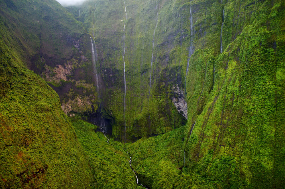
Mount Waialeale is a shield volcano which has been dormant since many years. Its unique shield like form was imparted by its fluid lava flows. The mountain got its low profile because of the low viscosity of its lava. This once upon a time active volcano, is now a rugged, lush green mountain range, regarded as the ‘wettest place on earth’. Thanks to the heavy rainfall that occurs here.
The Mt. Waialeale summit experiences an average rainfall of more than 450 inches per year. Due to this, the rainwater flows through the crevices in the steep walls, giving the mountain a weeping appearance. The word Waialeale means “rippling water” or “overflowing water” in Hawaiian. This rainy mountain couldn’t have got a better name.
Also, the famous Wailua River originates from the the Mt Waialeale summit. It is formed as rainfall collects in two main forks flowing down Mt Waialeale. The course of these forks are joined by numerous streams along their way. Gradually, both the forks join each other making the Wailua River wide and easily navigable.
Why is Mt. Waialeale the rainiest place on earth?
Owing to the facts, Mt. Waialeale is the second rainiest place on earth. The first place goes to Mawsynram in India.
Different parts of Kauai experience different levels of rainfall. The north shore is mostly wet throughout the year whereas the south shore is best known for its sunny days. Then, why does Waialeale experience such heavy rainfall?
There are a number of reasons to this. But, the most logical ones would be its location and topography. Owing to its central location, the conical round summit traps the misty air blown from the ocean. The mountain is naturally designed in such a way that its steep walls allow the light humid air to rise quickly. This facilitates the growth of cloud droplets and causes them to condense and allow a large portion of rain in one place. The cloud accumulations in the region are quite large which explains why Mt Waialeale gets heavy rainfall.
How to see Mt Waialeale?
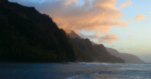
This is a very tricky part, because Mt Waialeale is almost always covered with clouds. Consider yourself extremely lucky if you get a good look at the big guy from a distance. The mountain is better viewable early in the morning, when the clouds are not yet fully formed.
If splendid views of the Mount Waialeale from a distance is all you need, then the Kuilau Ridge trail is an excellent option. It starts from the Keahua Arboretum and further extends as Moalepe Trail, leading to a footbridge over the Opaekaa stream. Combined with stunning views of Waialeale, you can also access other wonderful places along the trail.
Another way to see the Mount Waialeale summit is through the Alakai Swamp Trail that starts from Kokee State Park. The alakai swamp is located towards the west of Waialeale. This is the world’s highest swampland and rain-forest, and is fed by the abundant rainfall on Mt Waialeale’s slopes. The rainwater drains directly into the swamp causing it to be wet and muddy. However, you don’t have to worry about getting all wet and muddy along the hike as the trail has been devloped by boardwalks.
Mount Waialeale can also be seen from the Puu O Kila lookout in the Waimea Canyon State Park. It contains a signboard pointing to Mount Waialeale. The Pihea Trail that starts from the lookout, gradually joins the Alakai Swamp Trail after about 2 miles. If you follow the trail further, you will be in for splendid views of the mountain range.
If you can go for it, it is worth taking a helicopter tour to scan the entire magnitude of the giant mountain. This is also the best possible way to witness the Waialeale summit. The lining of waterfalls that flow along the mountain walls impart a beauty that can only be best enjoyed by seeing from above.
The Blue Hole Hike
The base of Mount Waialeale is commonly called the Blue hole. This is the crater from where you can see the weeping wall of the mountain. The blue hole hike, is extremely challenging and is suitable only for hikers with a lot of experience.
With Waialeale being regarded as one of the wettest places on earth, you know what to expect when you go for a hike to the mountain base. The blue hole hike, or the hike to Waialeale falls, is not an official hike. Unlike the popular hiking trails on the island, there is no definite route to access the Waialeale crater and there is always a risk of getting lost, numerous times! There are very few experienced locals who have accessed the blue hole. Moreover, the hike is not a pleasant one. It involves crossing lush green jungles, walking through knee deep mud, crossing river streams and climbing waterfalls.
A sudden outburst from the clouds can cause flash floods in the Wailua River. There have also been instances where hikers were trapped in the jungles for days without supplies and had to wait till the water levels had subsided. So, its of prime importance to notice the weather conditions. The slightest hint of changing weather is a signal to back off, before it’s too late.
If you still feel the need to give it a try, its best to consult an agency that provides hiking tours to the Waialeale valley as they have knowledgeable local guides and 4X4s for a safe and pleasurable experience.

Final Words
Getting to Mount Waialeale is difficult. But, this makes it all the more special and a ‘must see’ because nature is fair and equally rewarding for the work it demands. Plan your visit properly for a safe and pleasant experience and also for crossing off “visiting one of the wettest places on earth” from your goal list!